Mu Ko Ang Thong National Park is an archipelago in the gulf of Thailand consisting of 42 separate islands, the principle islands being;Phaluai, Wua Ta Lap, Mae Ko, Sam Sao, Hin Dap, Nai Phut and Phai luak. All the islands occur in Ang Thong district, of Amphur Samui, Surat Thani province. The park covers a total area of 102 sq.km of which about only 18 sq.km is land. The National park does not encompass the entire island chain, its jurisdiction covers about 82% of the total area. The park was established on 12th November 1980.
Geographical Features
Mu Ko Ang Thong National Park consists of 42 islands. Its main islands are, for examples, Phaluai Island, Wua Chio Island, Wua Talap Island, Mae Ko Island, Samsao Island, Phai Luak Island, Kha Island, Hindap Island, Phi Island, Wua Kantang Island, Mae Yat Island, Wua Te Island, Naiphut Island, Changsom Island, Hanuman Island, Thaiphlao Island, Huaklong Island, and Kho Ban Island.Most of the islands consists of limestone mountains about 10-400 meters above sea level. Because the limestone can change its structure easily by both chemical condition and weather, so that makes the islands have many, strange-looking caves and cliffs, and some islands are looked like ancient Angkor Wat in Cambodia and Prasart Hin Pimai.
 Weather Condition
Mu Ko Ang Thong National Park has been influenced by monsoon that causes big waves and heavy rain, approximately 2,000 mm. of rain all the year round, and the temperature is approximately 23 oC. The appropriate time for visiting the islands is between February and April, although the temperature is quite hot but the sea is calm suitable for sailing.
During monsoon (November and December) in the Gulf of Thailand always have big waves and windy. Traveling to Ang Thong National Park, Surat Thani Province is not safe. Thus, National Park office announced for temporary closing during 1 November - 23 December every year.
 Varieties of Plants and Wild Animals
The islands of the park are covered in forest of four types;
Dry Evergreen Forest, occurs on the larger islands with significant patches on Wua Ta Lap,Phaluai and Sam Sao. The principle tree species are; Memecylon sp., Barringtonia fusiformis, Semecarpus curtisii, Cinna- momum sp., Caryota spp., Calamus spp. and Paphio- pedilum niveum "Ang Thong" Pfitz.
Beach Forest, occurs in a narrow strip around most of the larger islands, especially in the area above high water mark on beaches. Species occuring include; Terrminalia catappa, Thespesia populnea, Carophyllum inophyllum, Scaevola taccada, Erythrina fusea, Pandanus monotheca and Crinum sp.
Limestone forest, occurs on the exposed cliff faces and in the very shallow soils on top of the limestone hills. Most of the plants found here are small and highly adapted to survive in the severe environment, species recorded include; Dracaena loureiri, Euphorbia antiquorum and Morinda sp.
Mangrove forest, occurs in the very sheltered spots where sandbars and mudflats have developed. This forest type is best represented around Mae Ko island and on the eastern side of Phaluai island. These forest areas are well structured with many trees, both large and small, the dominant species is Rhizophora apiculata.
On the larger islands with areas of undisturbed forest many species of animals are present. Occasionally seen are Spectacled langurs, Hairy-nosed otters, bats, Pacific reef-egret, Brahminy kite, White-bellied seaeagle, Common sandpiper, Edible nest swiflet, Oriental pied hornbill, Southern pied hornbill, Ashy drongo, Collared kingfisher, Monitor lizards, Tortoises, Sea Turtles and Pythons.
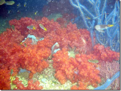
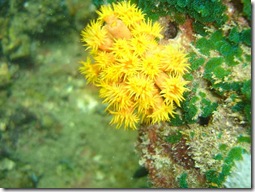
 The area of the Gulf of Thailand in which the islands are situated is at a maximum 10 meters deep. The islands rise up out of the water and are thus surrounded by water which is relatively shallow. This means that the water is greatly influenced by turbid river water from the mainland, the river water does not encounter deep water which will reduce its velocity and thus allow carried sediment to settle out. The water around the islands is thus fairly turbid all year round. The coral development on the islands is not extensive and is restricted to a narrow band encircling each island close to the shore, especially on the southwestern and northeastern sides. Although the Northwestern side of the islands is the area most influenced by the monsoon, in sheltered spots good corals develop especially; elephants tusk coral, brain coral, stagshorn coral and in deeper water plate corals of the genus Pavona and flower corals of the genus Goniopora. Animals found inhabiting these reefs include; Butterflyfish, Angelfish, Parrotfish, Stingray, Black tip shark, Grouper and Cowrie shells.
In areas where the water is not so clear or is subjected to strong currents the species diversity is poor and is dominated by Seaworms, Crabs and brown seaweeds, of the genus Sargassum and Turbinaria.
In places with steep rocky shorelines or where the water is very turbid coral cannot survive. In these areas sedentary marine life is prevalent including; Sea fans, Oysters, Clams and Mussels, which can be seen covering the exposed rock surfaces.
 The water of the gulf of Thailand is very rich and provides a valuable resource upon which a rich diversity of animals and plants are able to thrive. This richness is long established and thus the seas around Ang Thong are plentiful. Species commercially collected are Softcorals, Penshells, Sponges, Seaweeds and Barnacles, important fish species caught include; Mackerel, Anchovy and Squid.
Location and Journey
Mu Ko Ang Thong National Park
145/1, Talat Lang rd, Talat Sub-district,, Muang Surat Thani, Surat Thani, Thailand 84000
Tel. : 0 7728 6025 begin_of_the_skype_highlighting 0 7728 6025 end_of_the_skype_highlighting, 0 7728 0222 begin_of_the_skype_highlighting 0 7728 0222 end_of_the_skype_highlighting Fax : 0 7728 6588
Head's name : Satid Tontikittiya Position : Administrative Forest Officer 7
By Car
Use national road number 35 (Thonburi-Paktho) from Bangkok to national road number 4 pass Phetchaburi province, Chumphon province, and Prachuap Khiri Khan province to national road number 41 to Surat Thani province, approximately 644 kilometers. ( Bangkok to Koh Samui air-bus fare = 745 Baht.) Go on to Donsak District and on board a ferry from Donsak District for another 60 kilometers.
 By Airplane
By Thai Airline Public Co, Ltd. from Bangkok to Surat Thani province. The airfare is 2,055 Baht.By Bangkok Airway Co, Ltd. from Bangkok to Samui Island. The airfare is 3,180 Baht. There is return flight every day, and about 1:15 hour a trip.
By Ship
Traveler can set off from Samui Island to Mu Ko Ang Thong National Park about 35 kilometers with 1,100 Baht a person by taxi-boat (tour boat).
 By Train
Use the train everyday from Bangkok (Hua Lam Phong) to Phunphin Train Station, and take a bus to Surat Thani Province and go further by bus of Surat Thani – Samui Island.
By Bus
Take a bus from Surat Thani to Ko Samui District about 84 kilometers with the air-bus fair = 210 Baht a person. from Ban-Don Seaport, Surat Thani Province, to Samui Island at 05.00 AM. And at 09.00 PM. from Samui Island to Surat Thani Province at 04.00 Am.

Thailand National Park : Mu Ko Ang Thong National Park ( Surat Thani National Park )

Thailand National Park : Mu Ko Ang Thong National Park ( Surat Thani National Park )

Thailand National Park : Mu Ko Ang Thong National Park ( Surat Thani National Park )

Thailand National Park : Mu Ko Ang Thong National Park ( Surat Thani National Park )

Thailand National Park : Mu Ko Ang Thong National Park ( Surat Thani National Park )


 The park occupies an area of 180 square kilometers in Mae Taeng Sub-district, Chiang Mai and Pai Sub-district, Mae Hong Son Province. The mountain, which is mostly ranged highlands, has verdant forests that are the sources of tributaries and various streams. Notable attractions in the park include Huai Nam Dang Viewpoint and Doi Kiu Lom, which overlooks Doi Chiang Dao. To get there, drive along Mae Malai-Pai Road to between Km. 65-66, and then take a 6-kilometer access road to the park office.


 Weather Condition
 Accommodations


 Flora and Fauna
 Weather Condition
 Varieties of Plants and Wild Animals
 The area of the Gulf of Thailand in which the islands are situated is at a maximum 10 meters deep. The islands rise up out of the water and are thus surrounded by water which is relatively shallow. This means that the water is greatly influenced by turbid river water from the mainland, the river water does not encounter deep water which will reduce its velocity and thus allow carried sediment to settle out. The water around the islands is thus fairly turbid all year round. The coral development on the islands is not extensive and is restricted to a narrow band encircling each island close to the shore, especially on the southwestern and northeastern sides. Although the Northwestern side of the islands is the area most influenced by the monsoon, in sheltered spots good corals develop especially; elephants tusk coral, brain coral, stagshorn coral and in deeper water plate corals of the genus Pavona and flower corals of the genus Goniopora. Animals found inhabiting these reefs include; Butterflyfish, Angelfish, Parrotfish, Stingray, Black tip shark, Grouper and Cowrie shells.
 The water of the gulf of Thailand is very rich and provides a valuable resource upon which a rich diversity of animals and plants are able to thrive. This richness is long established and thus the seas around Ang Thong are plentiful. Species commercially collected are Softcorals, Penshells, Sponges, Seaweeds and Barnacles, important fish species caught include; Mackerel, Anchovy and Squid.
  By Airplane
 By Train


 Flora and Fauna
 Wild Animals
 Just off Thailand’s south western coastal town of Krabi, on the east side of Phang Nga Bay, exists a unique, unspoiled tropical island: Ko Lanta Yai. Ko Lanta Yai preserves its community spirit in both family and business life. With clear, cool waters and superb white sand beaches stretching along a 27 kilometer coastline, its paradisiacal appeal remains unmarred by mass tourism. The island, which reaches a height of almost 500 meters at its extreme end, also boasts a mountain range covered with rain forest.
 The island itself runs from north to south, with the west coast established as the main tourist area, offering accommodations for all budgets, a variety of activities, and a choice of bars and restaurants. Picture-perfect sunsets can be seen from any of the many beaches, while the colorful local fishing boats known as “long tails” bob lazily in the foreground.


 This national park which covers an area of 1,005 square kilometers is located on Doi Inthanon, Thailand's highest mountain which is 2,565 meters above sea level. Located between Mae Chaem and Chom Thong, the park is comprised of the largest tract of upper mountain forest which ranges across Nepal, Bhutan, Myanmar, and ends in Northern Thailand. The mountain ranges gave birth to the main tributaries of the Ping river and formed the beautiful waterfalls, namely Siriphum, Wachirathan, Mae Pan, Mae Klang and Mae Ya. The moist and dense evergreen forest is abundant with lichens and wild orchids. The park is also a paradise for bird lovers.


 General Information
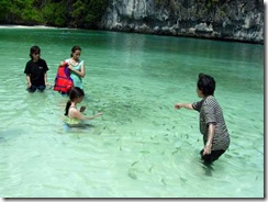 Climate
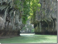 Flora and Fauna
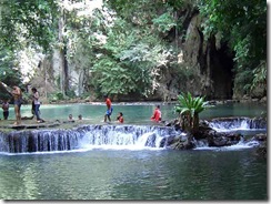 Wildlife